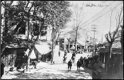
Το Σιδηρόκαστρο στο βιβλίο A HANDBOOK OF BULGARIA , 1920


An alternative road continues in a WSW. direction
down the Oseno valley till it reaches its confluence
with the Struma opposite Simitlii at mile 5. From
this point there is a track up the 1. bank of the
Struma joining the main Demir Hisar-Juma'-i-Bala
road at the bridge 3 miles N. of Simitlii (see Route
26 at mile 74i).

ROUTE 26
SERES—DEMIR HISAR—JUMA'-I-BALA, 83i miles
This is one of the principal strategical routes, providing a line of entrance into Bulgaria via the Struma valley from
the Salonica-Dedeagach railway at Demir Hisar. The light
railway from Juma'-i-Bala was reported (Jan. 1917) to have
been constructed as far as Rupel.
From Seres to Demir Hisar is a good chaussee (according to report of March 1916) through open cultivated country. The

soil is of hard clay and stony, providing good going in all weathers.
From Demir Hisar to Juma'-i-Bala is a chaussee, the greater
part of which, from the Karasu bridge (where the road
from Petrich comes in) to Juma'-i-Bala, has been lately
repaired, and is in very good condition (Jan. 1916). From
Petrich to the Kryesna defile the alternative road on the right
bank of the river is narrow, but good, fit for two -wheeled
traffic. The road is vulnerable at many points in the Kryesna
defile. The Struma is fordable only in a very few places
(see p. 141), and in the upper reaches its current is swift. For the section Seres-Demir Hisar see Handbook of Macedonia, Roads and Tracks, Route 98, miles 0-18|.
miles
Seres. Demir Hisar railway station with special military
facilities (see section on Railways) close SW. of road. Pulyovo 1 mile NE.
Road reaches lower end of Rupel pass at the point
where the railway crosses the Struma (alt. 180 ft.), and hills on E. give positions commanding the
approach up river from W. and SW. (defended by
the Bulgarians against the Greeks after retreat from
Doiran, 1913).
Branch tracks : (i) Up the W. bank of the Struma for 10 miles,
where it joins the road from Strumitsa and Petrich
(Route 32, alternative) and crosses the Karasu bridge
at 10J miles to rejoin the route at mile 31 below.
(ii) To Doiran (see Handbook of Macedonia, Route
95 at mile 39), W. by S. Road follows 1. bank of Struma N. beneath heights
which are closer to the river on this bank than on
the other. 23 Rupel.

Alt. about 213 ft. The valle}^ widens.
The road crosses the Bistritsa, a tributai-y of the
Struma, by a stone bridge. Greek-Bulgarian frontier. Kula. Hence road bends NNW. and farther from
river. According to the Greek official map, 1914, a road branches SW. across the river by Karasu
bridge (stone or iron) to Petrich (7| miles) and Strumitsa. (See Route 32.) From Petrich a road reported
to have been made fit for motor transport runs NNE.,
crosses the Strumitsa (3 miles), and runs up the W.
bank of the Struma, close to the river and main road
throughout, as far as the Kryesna bridge (see mile 60
J
below) for a distance of 26 miles. 4 miles S. of Kryesna bridge this road is crossed by a road from
Bresnitsa and Pehchevo (see Route 35 at mile 16|).
A road branches in a general direction first N.,
and later ENE. to Nevrokop (see Route 28).
Marnopole. j mile N. is Marekostinovo village.
A report of June 1916 states that a new road, fit for
field artillery, has been made from here NNE. to Melnik, about 7 miles. Road crosses a spur N. to valley of Melnishka
(tributarj^ of the Struma), crosses stream, and
ascends hills to N., diverging from river. According to the Bulgarian map (1914) the branch
road already mentioned under mile 31 above leaves the route at this point (see Route 32).
Road turns NNW., and returns towards river. Livunovo. The light railway from Juma'-i-Bala
passes this village. Trains reported (Jan. 1917)
running to Marnopole.
Cross the Gogovitsa river (stone bridge). Lyeshnitsa 1 J mile NNE. up valley. Road returns to Struma

valley, and crosses a series of broad cultivated ridges
with intervening affluents of the Struma, viz. Bistritsa (stone bridge, mile 42J), Gyumendzha (wooden bridge,
mile 45).
Han Byelitsa. Cross the Gogovachka river (wooden bridge). Cross the Saz Dere (stone bridge).
Han Gradeshnitsa. The road approaches the
Kryesna Derbend (pass), scene of the Greek advance
in 1913.
Salih Aga. A road branches NW. across the river
(large wooden bridge) and leads W. to Pehchevo (see
Route 35). Cross the Kirkitsa stream.
It is reported that from Yenikoi, | mile up this stream, a road turns N. across the hills (2| miles) by
a winding course passing between the villages of Vakanov (7 J miles) and Mechkul (SJ miles) and
rejoining the main road in 9
J miles (see mile 64)
after crossing the Struma by a strong wooden bridge
of one 60-foot span (1905). This appears to be a
disused stretch of the main road.
Road turns NE. awa}" from river, and winds up the
side valley of the Sheitan Dere, IJ mile, then crosses stream by a wooden bridge, and returns W. 1 mile,
winding back to main valley.
Road crosses the Struma by the Kryesna bridge to W. bank, and continues up the valley, entering the
steepest part of the gorge. The gorge is nearly
7 miles long. The river and steep heights are to E. of the road, wooded hills to W. A flanking move- ment is possible against an army which holds the
defile. Alternative road from Petrich (see mile 31
above) enters from S. Alternative track mentioned under mile 56J above is said to enter from SE. Road continues along a narrow